
Coming out of Gabriel's, kicking a leg over the bike, getting the last bit of chatting in with my friends, I watched a guy lean on the horn for something like 10 seconds behind another driver who was waiting at a red light to exit the parking lot. My friends and I looked at each other, baffled. The cars were both in a separate lane which only had the option of going straight through, or left. The light was clearly and obviously red. The driver in back was clearly very, very angry that the driver ahead of him wasn't turning left through the red light.
This is an encouraging thing to watch, when you're about to head out of the parking lot, across six lanes of road, and turn left to head down Bank with a right-turn lane on your right. On a bicycle.
Once I'd left the parking lot, I continued on Bank, past South Keys Mall on my left. At this point, Bank is two or three lanes wide, depending on the turn lanes, which come and go. The posted speed limit is 50 km/h.
The posted speed limit is a joke. This road was, until 18 years ago, Ontario Highway 31.
Past Johnston, I get to take the bridge over the train tracks. Fun! These train tracks cut across the north end of Gloucester-Southgate Ward, slashing a line of blankness through the roadmaps, cutting off one community from the other and leaving a wasteland between them of abandoned ravine, unused "park," empty lots, a drainage lagoon, hydro towers, and some industrial buildings. Oh, and the paved desolation of the Greenboro Park-n-Ride.

You see that one road, just about in the middle of the image? You see how it goes right up to the tracks, stops, then starts again just south of the tracks? That's Albion. That road is the sign and emblem of the whole severed, truncated, isolated neighbourhood. Mon pays, c'est that road.
The bridge has lousy pavement and the added spice of knowing that cars might come flying over the crest without seeing - or expecting - a cyclist. Is my taillight working? Is it bright enough? Should I have more taillights? Can they even see me? Speeds here, as further south on Bank, are usually much higher than the posted 50 km/h limit.
On the other side of the bridge, I can duck right on Kitchener Ave, and after that things are pretty calm. And then I'm home.
Traveling north/south in this city, by bike, is orders of magnitude nastier than traveling east/west. The city's mostly strung east to west along the Ottawa River: that might be it. There's also the uncomfortable truth that the south end of Ottawa - particularly Herongate/Alta Vista/Ledbury, the neighbourhood I'm getting increasingly militant about calling mine - is economically disadvantaged, with a high proportion of minorities and new immigrants. But Bank Street is the major north/south road in the city of Ottawa. And sooner or later, if you live near it, you have to deal with it. In my area, that means if you want to go to South Keys Mall, or the Greenboro Community Centre, or to visit a friend in the South Keys neighbourhood, there is no reasonable way to get there without taking Bank Street, whether you're in a car, on a bike, or on foot. Ditto if you want to go north, toward downtown.
And Bank Street is a highway. It's Ottawa Route 31. Formerly (until 1998) Ontario Highway 31. You can dress it up with 50 km/h speed limit signs but face it: it was designed for 70-80 km/h and it feels downright silly to try and drive down this sweeping, six-lane thoroughfare at 50 or even 60 km/h. You really can't expect people to go that speed on a wide, multilane road past big-box stores, sound barrier walls, car dealerships, and park-n-rides.
So what do you do? You take bikes (and pedestrians) off it. If you can't make your main north-south artery - for the whole city - reasonably safe for cyclists and pedestrians, then they shouldn't be forced to use it. Nothing that comes with a little shield with a number on it on the road maps should be considered acceptable for bicycles. Build a parallel bike track.
Or, if your bike track is too hard to build onto your train bridges and overpasses, find other routes nearby that connect the same key nodes. In this case, Albion. (Remember Albion? Up there in the image? Hi, Albion!)
What we need is a pedestrian and bike bridge connecting the north and south stubs of Albion Road. This is my route to a friend's place in South Keys, as it stands:
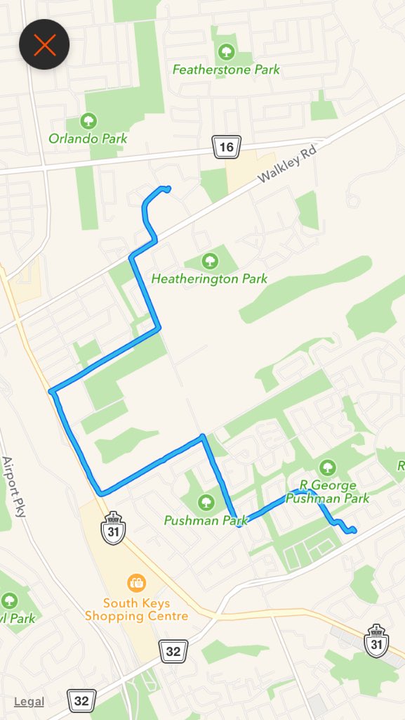
That huge diversion over to the west, onto a former highway, and then back (via a left-hand turn across three lanes that puts my heart in my mouth, by the way) could be cut out entirely by a pedestrian/bike bridge on Albion, over the tracks.
I'd be able to just go straight across on Albion, without that big U-bend in my trip. I wouldn't be trying to "share the road" with 80 km/h cars. Pedestrians could get from one side of the tracks to the other without walking the laughably narrow sidewalks over the bridge with trucks thundering past. The parkland on either side of Albion might actually get developed into something other than an overgrown and underused ravine full of vines and blown-in garbage.
And one more connection between neighbourhoods, in an area sadly full of isolated and cut-off neighbourhoods with roaring car-dominated streets between them, would be made.
No comments:
Post a Comment